For decade, this swastika of larch trees stood undiscovered in the
middle of dense pine forest near the village of Zernikow, about 110
kilometers (68 miles) northeast of Berlin. After the Nazi symbol was
discovered in an aerial photograph in 1992, a scandal broke out that did
serious damage to the area's reputation.
A forestry worker cuts down one of the larch trees in December 2000
after the swastika formation had drawn international outrage for a
second time. The felling of the formation, which is 60 meters (197 feet)
on each end, was only approved by the owners after much wrangling.
The planting of swastika formations, like this one near the town of
Asterode in the western state of Hesse, was popular among foresters
throughout various regions of Nazi Germany. There were many swastikas in
the forests surrounding Berlin until they were removed under Soviet
occupation.
In this same wooded area of Asterode in Hesse, the numbers "1933," the
year Hitler came to power, were spelled out in larch trees across a
backdrop of pine forest, bursting into color in autumn. The eyesores
remained for a long time, until the early 1960s, when American occupying
forces discovered the trees during an aerial reconnaissance flight and
complained to the local government.
Not only the swastika was immortalized with trees. This small forest in
Bavaria was planted in the form of an iron cross in 1920, as this Google
Earth shot from Jan. 1, 2008 reveals. Still today, a nearby plaques
advertises the "Iron Cross Natural Monument."
With the help of Google Earth, numerous online forums are devoted to
identifying Nazi symbols that are visible only from the air. In 2005, a
user of the online form bunker-nrw.de noticed this swastika in a pine forest in North Rhine-Westphalia and marked it with arrows.
In 2006, the New York Times reported the discovery of a
swastika-shaped forest in Kyrgyzstan. But the mysterious horticultural
formation only resembled the Nazi symbol when viewed from the nearby
village of Tash-Bashat at a very specific angle. From the air, the
woods, here in the center of a Google Earth shot from June 18, 2006,
look more like the leter "k."
While most German forest swastikas were created by card-carrying Nazis
in the 1930s, the symbol has also occurred more recently. It's still
unknown who trampled this swastika into a Bavarian corn field in August
of 2010.
In the 1930s, Nazis constructed the entire South Hessian village of
Hessenaue in the shape of a swastika. After the fall of the Third Reich,
the village tried to get rid of the shape -- and yet its basic features
can still be spotted on aerial photographs.
This village to the east of Jena was supposedly built in the shape of a huge imperial eagle.
Not every Nazi symbol in an aerial photo was intentional. For decades,
no one noticed the insidious form of this naval base in San Diego. But
in 2007, with the help of Google Earth, the swastika shape was
discovered and citizens demanded the building be torn down.
The Wesley Acres retirement home in Decatur, Alabama is another
accidental swastika. In 2008, the building's shape came to the attention
of a Jewish activist group, which successfully lobbied to have the
government-funded building altered.
Article from Der Spiegel.

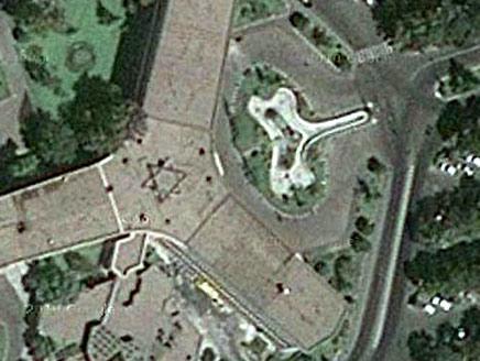
Iranian university building from Google Earth

Those sneaky Jooooooooooooooos!
A satellite image from Google Earth of the headquarters of Iran’s national airline reveals a Jewish Star of David right in the middle of the roof.


1 comment:
The swastika on the Naval base was definitely intentional, as someone within the government had to approve of the initial drawings.
People don't just start building a building by throwing bricks down wherever they want lol.
The fact that it hasn't been demolished yet is very telling of our government...
Post a Comment